As the geographic information systems specialist in the Center for Coastal and Watershed Studies (CCWS) at Hood, Smith compiles data using R, a programming language for statistical computing and graphics, and then he creates interactive maps using ArcGIS to present the data in a visually easy-to-understand way.
Smith says he has made hundreds of maps using this method. His projects for the CCWS have included a bathymetric survey of Fishing Creek Reservoir for Frederick County (this is the underwater equivalent of a topography map), ongoing utility mapping for the Hood campus, and mapping microbial source tracking (determining the sources of fecal bacteria in bodies of water).
 He began posting some of his projects on dcist.com, a blog of D.C. locals, in December, and the DCPC saw his work and contacted him.
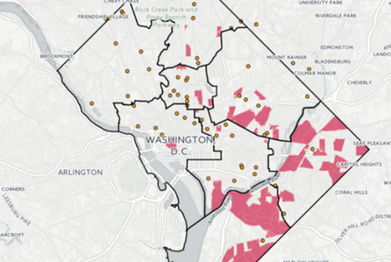
Since then, the DCPC has published approximately 15 of his statistical analyses, maps and charts. These include maps that show where there are food deserts in the city; how many people would be affected if part of the metro system shut down; and a heat vulnerability index, which identifies geographic areas of the city that have a large population of people who would be vulnerable to heat-related illnesses.
“Another one I am just finishing up for them is an analysis of the economic value of D.C.’s street tree forest,” he said. “Roughly, the street trees of D.C. contribute about $15 million of value per year to the city through energy savings and carbon sequestration.”
The street trees provide shade, which helps cut down on air conditioning costs, and they remove carbon dioxide from the atmosphere naturally so the city doesn’t need to pay for artificial methods.
The goal of Smith’s maps is to provide visual facts about important issues.
“It’s good to determine an actual number of people affected by decisions and policies,” said Smith. “DCPC employs maps/GIS to aid the local government in making decisions and formulating policy. One of the key benefits is that we create map interfaces that make complex problems and data easier to understand.”
Established in 2016, the D.C. Policy Center is a non-partisan think tank committed to advancing policies for a strong and vibrant economy in the District of Columbia.
For more information about Randy Smith and his projects, visit www.rhsmithjr.com.